I just got home from the successfully concluded game; thanks to all the players for their good humor, play, setting up, taking down, providing troops and terrain - a true team effort! Before I start with the after action report, I thought I'd go over how I generated the set-up for the multiple tables. The (very, very nice) venue at The Time Machine in Manchester, CT dictated that we would have eight or nine 4 by 6 foot tables available, plus I brought my own 3 by 6 foot folding table. As it turned out, there were plenty more tables of that size available but I still used my own. Now, the trick was to convert the strategic Theater map into a series of wargames tables, generally having the edges of the tables formed by rivers, mountain ranges, or woods.
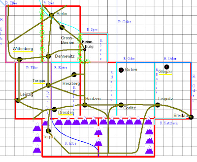
Here is the overall Theater map for comparison. This is the map the players would work from in planning their moves (and keeping their orientation!) (with the above in mind, I made some changes to the geography to better divide it into wargames tables):
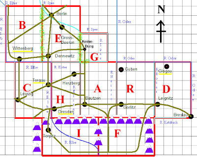
Next, I assigned a Letter code to each table, in no particular order. OK, well actually, it spells out a silly phrase "Beg Chard If", but that was just some minor whimsy on my part. As all the tables would be in full view of one another, the idea was to have them be distributed randomly, and with random orientation (North-South-East-West) with regard to the room and each other. Here is the same map with the table codes added:
Then I used MSPaint to "cut" out each of the tables and save them as separate files. At this point, because I wanted to maximize the "Fog of War", I labeled all the rivers, but deleted (erased) the names of the Cities and towns. In order to carry this off in a reasonable time frame, all the players would be setting up the terrain at least one table. This would keep if from being too obvious which table fit where on the overall strategic map.
Table A; the Town is Bautzen.
Table B - the yellow underline of the (missing) name of Wittenberg indicates that this is a Fortress!
Table C - Leipzig is to the East, and the Fortress of Torgau is to the West, guarding the crossings over the Elbe.
Table D - Breslau is in the Southeast, Leignitz is to the West, and the Fortress of Glogau is to the North. In considering the likely development of the game, I later added a bridge (without a major road) over the Oder near the Fortress. Although this is off the active playing area, I had in mind that Russian Reinforcements under Bennigsen might enter here if there were sufficient players/late arrivals.
Table E - to the Southwest is Dennewitz, to the North is Berlin, and towards the middle is Gross Beeren.
Table F - South of the Erzgebirge mountains; no cities or towns in this somewhat desolate area.
Table G - a small bridging table with the Town of Keineburg on it.
Table H - to the Southwest is the Fortress City of Dresden, to the Northeast is the Town of Herzberg.
Table I - also to the South of the Mountains; the town is Torplitz.
Table R - to the Southwest is the Town of Gorlitz, and to the North is the Town of Guben; once again in considering the likely flow of the game, I later added a bridge (but no primary road) over the Niesse near the town.
Having created those files, I then went back and added the minor terrain, based very loosely on the general nature of the ground in that vicinity. That [produced the following individual maps, which the players would use to set up the tables, and would stay on the table as a North/South Orientation guide (the top of the map is always North). The squares outlined in orange are villages. I made labels for all the Towns, Cities, and Fortresses to place under their buildings, concealed. These would be revealed when they were scouted.
In the event, the final roster of players and commands was:
ALLIES:
Bernadotte (Joe) - Army of the North; mixed Swedes, Russians, and a few Hanoverians
Sievers (Barry) - Russian Cavalry Corps (with many Cossacks)
Blucher (Russ) - Prussians
Schwarzenberg (Dan)* - Austrians
"FRENCH":
Oudinot (Roger) - Bavarians
McDonald (Greg) - Saxons
St. Cyr (Peter D.) - French
Ney (James)* - French
* = C-in-C
Dim, blurry Overview of some of the tables.
Bright, blurry overview of some of the other tables!
Ney started within 12" of Bautzen
and headed North, soon encountering probing Cossacks from Sievers' Cavalry Corps!
A French garrison holds the Fortress at Wittenberg and the Elbe crossing.
"All quiet on the Western Front..."
Oudinot started within 12" of Torgau (all four of the Fortresses were held by the French and each had a n immobile independent garrison of 2 Infantry units and one 6# artillery unit, all rated as Experienced).
Blucher started within 12" of Breslau.
and soon heads off to the West. "Vorwarts, meine Kinder!":
Bernadotte started within 12" of Berlin.
and quickly headed South across the river Spee... Swedes in the lead!
No one started on this table, nick-named (by me) "Lonely Mountain".
Sievers started within 12" of Keineburg.
Now that's a lot of Cavalry; he was ordered to Probe forwards in both directions, and report what he found to the Allied C-in-C.
St. Cyr started within 12" of Dresden
The exact nature of his initial orders seems somewhat unclear.
Scwarzenberg started within 12" of the bridge over the Elbe to the Southeast.
and moved West initially, heading for the Mountain passes South of Dresden, before changing directions back to the East, evidently based upon Reconnaissance reports.
McDonald started within 12" of Gorlitz.
and began to withdraw towards Bautzen.
Schwarzenberg's troops enter Table F (lonely Mountain).
and St. Cyr's Corps moves West across the Elbe; Torgau (and Oudinot's Bavarians) is to the top of the picture, and Leipzig is off the picture to the left.
James made up a large scale version of the Theater map, and set it up on an empty table to help try to keep track of the big picture, using left over figures as markers. Where is Bacler d'Albe when you need him?
To be continued...
Peter


A great read over my morning coffee Peter. Looking forward to the rest of the campaign.
ReplyDeleteSteve
Glad you enjoyed it, Steve - I have anopther 75 or sop pics to go! :-)
DeleteObviously you put a lot of thought and prep into the game. It was a nice effort, Roger and I had a lot of fun. We did get stuck in very early near what turned out to be Leipzig. Roger's reaction to receiving orders was classic.
ReplyDeleteConsidering how low the average knowledge of the rules was at the start of the day, it was incredibly smooth. A very good set of rules for what it sets out to do: play a complete campaign over a lot of tables with a large group of players, a manageable multitude of figures,all in a single day.
Yes, you and Roger got stuck in early on, so largely had a tactical battle on the day! I agree that the rules work well for what they set out to do - both this and full size Napoleonic battles on a tabletop of reasonable size. I would consider running all of Leipzig with SN - we would have more than enough troops, and the space required wouldn't be outrageous. Each of the "Corps" that we used actually represented roughly 60,000 men in normal SN scale... and even with 25mm troops, each one fit in a single letter sized Very Useful Box!
DeleteAnd you are right - the rules are *very* easy to pick up. Doubtless some things were done wrong, but none that would be game changers, and most are apparent after reading the rules over the following day.
DeleteDo you make any allowances for ground scale etc. when using 28mm figures, or do you just play Snappy Nappy as written?
ReplyDeleteWe used the same measurements/ranges etc as in the rules. Actually, the base sizes we used (about 1.5 to 2" frontage, despite using troops from five different collections - would have been seven as originally planned) are pretty much what the rules call for anyway.
DeleteWe played them as written, they worked well enough at the level aimed for in the scale of the game. It is really about acting at Corps commander or theater CiC level.
ReplyDeleteVery nice loking game, I love the maps and explanations...and very nice march colomns too!
ReplyDeletePhil.
Very interesting stuff glad the effort expended was worth it
ReplyDeleteWow, a fine project,
ReplyDeleteLooks great!
Thanks, guys! It was well worth it.
ReplyDeleteSolendid. A lot of work with great results!
ReplyDeleteThanks! I enjoy your blog as well.
DeleteThis is very cool. I'm going to have to pick up a copy of these rules. Can I possibly use my V&B bases with this system?
ReplyDeleteI think you will find them well worthwhile, especially for a project of this nature. I would think the V&B bases would work fine and look great for SN! As long as they are all roughly the same frontage it should work fine. Hat is the frontage of your bases, Mike?
DeleteYes very very interesting......inspiring stuff indeed.
ReplyDeleteGlad you found it of interest!
DeleteAn elucidating description of the set-up Peter. You are a true workhorse putting all this together AND then reporting it for the pleasure of your e-mates!
ReplyDeleteJames
(p.s. I was also previously totally ignorant of Louis Albert Guislain Bacler d'Albe!)
Thanks, James. It was a lot of work, but it was quite a fun project.
DeleteI'm surprised you were unaware of Bacler d'Albe, although I suppose the fact that he has a detailed wiki article in French but none in English is telling to a degree! In Chandler's book, there is a fairly lengthy description of the organization and functioning of Imperial Headquarters, and the image that he gives of Napoleon and d'Albe crawling over the maps, sticking in pins, etc has stuck with me!
Uau, maravilhoso seu layout! Há quanto tempo você tem
ReplyDeletesite? O aspecto geral do seu web site é incrível, assim como os temas que aborda!